news

Be informed
Read the latest documents which tells you what kalteng consultants is doing.
- 2016 Marrakech Action Proclamation for our ...
- Peatland Restoration Agency, Republic of ...
- 2015 United Nations Climate Change Conference in ...
- Indonesia's Silent Tragedy in a Connected World ...
- Report by John Macdonald about the ongoing peat ...
- Indonesia's Fire Crisis — The Biggest ...
- Carbon emissions from Indonesia’s peat fires ...
- Get Your Facts Right on Indonesia's Haze
- Indonesia president visits forest fires amid smog ...
- Again El Nino year 2015: Hot Spots from Borneo ...
- El Nino year 2014: Hot Spots from Borneo taken on ...
- UNFCCC-Warsaw Conference - Framework for REDD+ ...
- Disappointing outcome for forests in Doha, but ...
- Governors Climate and Forests Rask Force, GCF, ...
- 2011 LIDAR- and RGB-Survey in Kalimantan ...
- UNFCCC Climate Summit in Cancún, Mexico, COP16; ...
- Reducing emissions from peatlands under REDD, WI ...
- Palangka Raya Declaration on REDD+ and MRV in ...
- Excursion to the burned Taruna-Base Camp in Block ...
- PRESS RELEASE. RAGING FOREST FIRES THREATEN WILD ...
- Milan Geoservice Calendar with Indoneisan ...
- An Investigation of LiDAR Data Processing in ...
- Successful Helicopter Flight Trials with Airborne ...
- Kalteng Consultants had an audience with the ...
- Declaration on the Heart of Borneo Initiative, ...
- 2006 Fires in Kalimantan, next El Nino Southern ...
- Suwido Limin, director of UNPAR/CIMTROP Fire ...
- The Amount of Carbon released from Peat and ...
- Kalteng Consultants Office, since
gallery

image gallery
Find a large collection of images from many years of exploration by kalteng-consultants.
news
2011 LIDAR- and RGB-Survey in Kalimantan

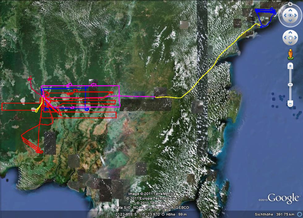
Figure: Airborne LiDAR Survey with 3.5 Lp/m² in average between 29.7. - 7.8.2011 in East and Central Kalimantan; Balikpapan, Sambodja Lestari and Bukit Suharto and Palangkaraya with Ex-Mega Rice Project and several peatlands between Katingan and Barito
by Viktor Boehm, Veraldo Liesenberg, Juergen Frank, Suwido Limin
presented at 3rd International Workshop on "Wild Fire and Carbon Management in Peat-Forest in Indonesia" sponsered by JST-JICA, in Palangkaraya, Auquarius Hotel, 22-24 Sept. 2011
Abstract
Natural tropical Peat Swamp Forests (PSF) are important for their rich biodiversity and because they represent important carbon pool (Page et al. 2002). However, PSF are decreasing due to conversion into farm land, by excessive draining, the use of shifting cultivation on a large scale, pal oil plantation, illegal logging and forest fire. This increases the interest for understanding in an ecological point of view and mapping such environments as they are recognized as an important source of carbon released in the atmosphere (Sorensen 1993, Page et al. 2002, Jaenicke et al. 2008, Ballhorn et al. 2009, Boehm et al. 2010).
According to Hyde et al. (2007) airborne Light Detection And Ranging (LiDAR) data is nowadays the best remotely sensor to investigate biophysical parameters (e.g. tree height and canopy diameter which are strongly correlated with above-ground biomass and leaf area index (LAI) (Hajnsek et al. 2009). In peatland areas the great variety of ecosystems and its ecological rule is still not fully understood. The influence of selective logged areas (e.g. species composition, their structures and canopy properties) on global change issues also remains therefore a big challenge. Consequently, to optimize the biophysical properties characterization, a better understanding of how LiDAR measurements could be useful for ecological studies in such critically endangered forests is still necessary.
In August 2007 and 2011 we mapped by helicopter different PSF transactions with Riegl LiDAR Technology (LMS-Q560) in Central Kalimantan, Indonesia. In this study, our main objectives were: a) to describe our activities during the multi-temporal LiDAR survey; b) to evaluate the peat swamp forest resilience with multi-temporal LiDAR observation; and c) to demonstrate our future activities concerning to the applicability of LiDAR technology in different environmental applications. Additionally, we demonstrate first results of our second LIDAR survey made in August 2011. We found by multi-temporal LiDAR approach that in an undisturbed tropical PSF area the average tree-height increased from 15.32m to 17.18m by difference of 1.86m which is 12%. The presented LiDAR-methodology can be promising in the frame of the REDD+ (Reducing Emissions from Deforestation and forest Degradation) knowledge of tropical peat swamp forests. The LiDAR technology supports the MRV aspect of REDD+ (Monitoring, Reporting, and Verification).
Keywords: Peat Swamp Forest, LiDAR, ALS, REDD and EMRP.

