news

Be informed
Read the latest documents which tells you what kalteng consultants is doing.
- 2016 Marrakech Action Proclamation for our ...
- Peatland Restoration Agency, Republic of ...
- 2015 United Nations Climate Change Conference in ...
- Indonesia's Silent Tragedy in a Connected World ...
- Report by John Macdonald about the ongoing peat ...
- Indonesia's Fire Crisis — The Biggest ...
- Carbon emissions from Indonesia’s peat fires ...
- Get Your Facts Right on Indonesia's Haze
- Indonesia president visits forest fires amid smog ...
- Again El Nino year 2015: Hot Spots from Borneo ...
- El Nino year 2014: Hot Spots from Borneo taken on ...
- UNFCCC-Warsaw Conference - Framework for REDD+ ...
- Disappointing outcome for forests in Doha, but ...
- Governors Climate and Forests Rask Force, GCF, ...
- 2011 LIDAR- and RGB-Survey in Kalimantan ...
- UNFCCC Climate Summit in Cancún, Mexico, COP16; ...
- Reducing emissions from peatlands under REDD, WI ...
- Palangka Raya Declaration on REDD+ and MRV in ...
- Excursion to the burned Taruna-Base Camp in Block ...
- PRESS RELEASE. RAGING FOREST FIRES THREATEN WILD ...
- Milan Geoservice Calendar with Indoneisan ...
- An Investigation of LiDAR Data Processing in ...
- Successful Helicopter Flight Trials with Airborne ...
- Kalteng Consultants had an audience with the ...
- Declaration on the Heart of Borneo Initiative, ...
- 2006 Fires in Kalimantan, next El Nino Southern ...
- Suwido Limin, director of UNPAR/CIMTROP Fire ...
- The Amount of Carbon released from Peat and ...
- Kalteng Consultants Office, since
gallery

image gallery
Find a large collection of images from many years of exploration by kalteng-consultants.
news
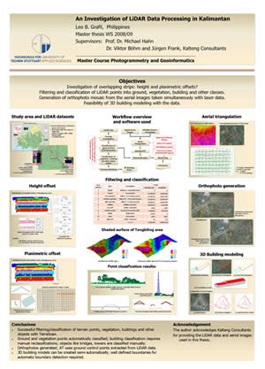
An Investigation of LiDAR Data Processing in Kalimantan, MSc Thesis by Leo B. Grafil; 27.02.2009
 Abstract
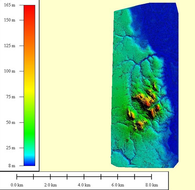
 Today, LiDAR is considered as a matured technology for direct measurement of earth’s surface and with further processing, in addition to Digital Terrain Model (DTM), a wide number of applications and products can be produced. It is extensively used worldwide especially in developed countries. But up to now its benefits are not realized in several developing countries like the Philippines.
The lack of knowledge, training, and qualified personnel could be attributed as one of its cause. Some LiDAR service providers’ delivers a mixture of first and last pulse point clouds in XYZ format only without additional information. As a standard practice quality check should be made before further processing. The objectives of this research are to study the handling and processing of such data. Filtering to derive bare earth, classification, and reconstruction of 3D building model were carried out with the LiDAR datasets from Kalimantan, Indonesia to fulfill the objectives. The characteristics of the said data were investigated first. This is followed by filtering and classification into different classes. Furthermore, datasets were used to construct 3D building models. All this tasks were implemented with Terrasolid software. Another part of the thesis is the generation of orthophotos from the digital aerial images taken simultaneously with laser scanner.
Exterior orientation parameters derived from the global positioning system (GPS) and inertial navigation system (INS) were used but does not give good results. Thus aerial triangulation was carried out first utilizing LiDAR data as ground control points (GCPs) because no GCPs are available. The Digital photogram metric workstation (DPW) from the Inpho company was used in this process. The processing and the results are all presented in this thesis. The results of filtering and classification were visually analyzed by taking the generated orthophotos into account. A DTM was successfully generated over urban and forested areas.
Other LiDAR points were also classified into different classes. Most of the constructed building models need manual editing which reflects the complexity of the roof and the point density of the LiDAR datasets. Keywords: LiDAR, Filtering, Classification, 3D Building Model, Kalimantan, Orthophoto Date: 27.02.2009 Supervisors: Professor Dr. Michael Hahn, HfT-Stuttgart, University of Applied Sciences Dr. Viktor Boehm, Juergen Frank, Kalteng Consultants