
lidar technologies

Lidar technologies
We measure distances by illuminating a target with a laser and analyze the reflected light.
- Biomass Situation of Mawas Region in Central ...
- Spatial and temporal variation of above ground ...
- Multi-Temporal Airborne LiDAR-Survey and Field ...
- Relating ground field measurements in Indonesian ...
- Assessing Carbon Changes in Peat Swamp Forest ...
- Multi-Temporal Airborne LiDAR-Survey in 2007 and ...
- Characterizing Peat Swamp Forest Environments ...
- Multi-temporal Helicopter LIDAR- and RGB-Survey ...
- Application of LiDAR data for analyzing fires, ...
- LiDAR Technology for peatland using DSM- and ...
- Small-footprint airborne LiDAR technology for ...
- 2006 Fire depth and tree height analysis in Block ...
- Relating tree height variations to peat dome ...
- LiDAR- / Airborne Laser Scanning mapping of ...
- Rungan Sari PCB, Draft Masterplan with LiDAR-DTM ...
- LiDAR Survey of Small Scale Gold Mining near ...
- Airborne Laser Scanning measurements in Central ...
- Peatland Topography of Ex-MRP measured with ...
- Rungan Sari Airborne Laser Scanning 3D-Model and ...
- Peat Dome Measurements in Tropical Peatlands of ...
- Erfolgreiches Pilotprojekt im tropischen ...
- Airborne Laser Scanning monitoring of Ex-MRP area ...
- Successful Helicopter Flight Trials with Airborne ...
- Successful Helicopter Flight Trials with Airborne ...
- OK Osaki Tsuji Boehm, Liesenberg- Appraisal of ...
gallery

image gallery
Find a large collection of images from many years of exploration by kalteng-consultants.
History Borneo - Kalimantan · Excursions to peatland 1996 · Mega Rice Project 1999 · 2004 · 2005 · 2006 · 2007 · 2008 · 2009 · 2010 · 2011 · 2012 · 2013 · 2014 · 2015 · 2016-March · 2016-August ·
lidar-technology
Characterizing Peat Swamp Forest Environments with Airborne LiDAR Data in Central Kalimantan (Indonesia), SilviLaser, Oct 2011
by Boehm, H.-D.V., Liesenberg, V., Frank, J, Limin, S.
In the Proceedings of the 11th International Conference on LiDAR, Applications for Assessing Forest Ecossystems. Hobart, Tasmania, Australia, 16-19 Oct 2011
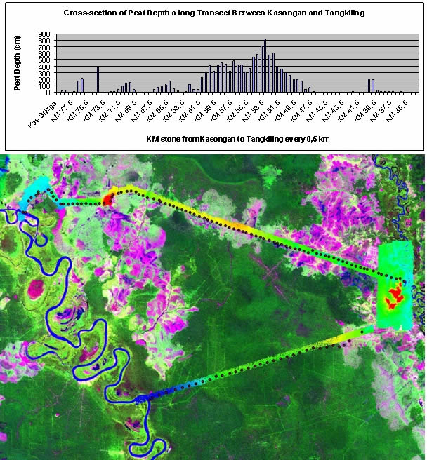
Peat drilling and LiDAR-survey 2007 between Katingan and Rungan river, res. Kasongan and Tangkiling cities
Abstract
We investigated how measures derived from both small footprints airborne Light Detection and Ranging (LiDAR) data and Ortho-Photo images can be used to characterize Peat Swamp Forest (PSF) environments in Central Kalimantan (Indonesia). In August 2007 we mapped by helicopter several transects using Riegl LiDAR (LMS-Q560) Technology. In this study, our main objectives were:
a) to evaluate the peat surface/profile and their associated domes;
b) to estimate the dependence of tree canopy height with both peat dome thickness and peat dome slope variations;
c) to estimate Above Ground Biomass (AGB) variations based on tree canopy height and physiognomy variations; and
d) to demonstrate the applicability of LiDAR technology to detect logging activities in tropical peat swamp forest environments.
Additionally, we would like to demonstrate the first results of our second LiDAR survey conducted in August 2011. We found that in an undisturbed tropical PSF area the average tree-height increased from 15.32m (2007) to 17.18m (2011) by difference of 1.86m which is 12%. This clearly shows the forest recovery capacity in secondary tropical PSF under protected conditions (e.g. conservation status).
Hence, we would like to demonstrate preliminary results of change detection method over this endangered ecosystem as well as the retrieval of forest attributes (e.g. AGB, LAI, Canopy Coverage, etc) in the frame of REDD+ knowledge.
Keywords: tropical peat swamp forest, tree height variations, peat dome slope, peat thickness, LiDAR, ABG, REDD+, MRV, Kalimantan
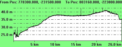
LiDAR profile between river Kasongan and Rungan showing a double peat dome
