
lidar technologies

Lidar technologies
We measure distances by illuminating a target with a laser and analyze the reflected light.
- Biomass Situation of Mawas Region in Central ...
- Spatial and temporal variation of above ground ...
- Multi-Temporal Airborne LiDAR-Survey and Field ...
- Relating ground field measurements in Indonesian ...
- Assessing Carbon Changes in Peat Swamp Forest ...
- Multi-Temporal Airborne LiDAR-Survey in 2007 and ...
- Characterizing Peat Swamp Forest Environments ...
- Multi-temporal Helicopter LIDAR- and RGB-Survey ...
- Application of LiDAR data for analyzing fires, ...
- LiDAR Technology for peatland using DSM- and ...
- Small-footprint airborne LiDAR technology for ...
- 2006 Fire depth and tree height analysis in Block ...
- Relating tree height variations to peat dome ...
- LiDAR- / Airborne Laser Scanning mapping of ...
- Rungan Sari PCB, Draft Masterplan with LiDAR-DTM ...
- LiDAR Survey of Small Scale Gold Mining near ...
- Airborne Laser Scanning measurements in Central ...
- Peatland Topography of Ex-MRP measured with ...
- Rungan Sari Airborne Laser Scanning 3D-Model and ...
- Peat Dome Measurements in Tropical Peatlands of ...
- Erfolgreiches Pilotprojekt im tropischen ...
- Airborne Laser Scanning monitoring of Ex-MRP area ...
- Successful Helicopter Flight Trials with Airborne ...
- Successful Helicopter Flight Trials with Airborne ...
- OK Osaki Tsuji Boehm, Liesenberg- Appraisal of ...
gallery

image gallery
Find a large collection of images from many years of exploration by kalteng-consultants.
History Borneo - Kalimantan · Excursions to peatland 1996 · Mega Rice Project 1999 · 2004 · 2005 · 2006 · 2007 · 2008 · 2009 · 2010 · 2011 · 2012 · 2013 · 2014 · 2015 · 2016-March · 2016-August ·
lidar-technology
LiDAR Survey of Small Scale Gold Mining near Kasonagan at Galangan area; 1-2009
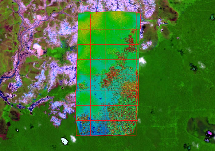
Galangan Small Scale Gold Mining area at Kereng Pangi near Kasongan scanned by
with an Airborne Laser Scanner and a RGB-camera to measure the sand-pit volumes
by
H.-D. Viktor Boehm, Juergen Frank,
Kalteng Consultants, 1-2009
On 8th August 2007 Kalteng Consultants flow with a Bell helicopter equipped with the ALS-sensor and a 22MB-Hasselblad camera over the Galangan Artisanal and Small Scale Gold Mining (SSGM) area and over the villages Kasongan and Kereng Pangi in Kecamatan Katingan, Central Kalimantan.
We gathered several single flight-tracks and 12 overlapping flight-tracks, which we processed to an ALS 4km x 8km grid as DSM- and DTM. Each tile has a size of 1km x 1km and is geo-referenced. They can be stored directly into a GIS.
Additional we gathered approx. 210 RGB/Ortho-Photos (4080 x 5440 pixels) and many Aerial-Photos.
So we are able to estimate the sand-volumes and number of holes, which were digged by the locals to collect alluvial gold with the toxic mercury (amalgam) technique. We simulate several water-levels for the area, for the holes and for the sand-pits.
The bio-mass of the remaining forest can be determined.
With this Hg-technique many locals are exposed to mercury vapours and global contamination of food e.g. fishes, which causes neurological damages to people and animals. Many mining pits and amalgamation ponds are remaining.
