
lidar technologies

Lidar technologies
We measure distances by illuminating a target with a laser and analyze the reflected light.
- Biomass Situation of Mawas Region in Central ...
- Spatial and temporal variation of above ground ...
- Multi-Temporal Airborne LiDAR-Survey and Field ...
- Relating ground field measurements in Indonesian ...
- Assessing Carbon Changes in Peat Swamp Forest ...
- Multi-Temporal Airborne LiDAR-Survey in 2007 and ...
- Characterizing Peat Swamp Forest Environments ...
- Multi-temporal Helicopter LIDAR- and RGB-Survey ...
- Application of LiDAR data for analyzing fires, ...
- LiDAR Technology for peatland using DSM- and ...
- Small-footprint airborne LiDAR technology for ...
- 2006 Fire depth and tree height analysis in Block ...
- Relating tree height variations to peat dome ...
- LiDAR- / Airborne Laser Scanning mapping of ...
- Rungan Sari PCB, Draft Masterplan with LiDAR-DTM ...
- LiDAR Survey of Small Scale Gold Mining near ...
- Airborne Laser Scanning measurements in Central ...
- Peatland Topography of Ex-MRP measured with ...
- Rungan Sari Airborne Laser Scanning 3D-Model and ...
- Peat Dome Measurements in Tropical Peatlands of ...
- Erfolgreiches Pilotprojekt im tropischen ...
- Airborne Laser Scanning monitoring of Ex-MRP area ...
- Successful Helicopter Flight Trials with Airborne ...
- Successful Helicopter Flight Trials with Airborne ...
- OK Osaki Tsuji Boehm, Liesenberg- Appraisal of ...
gallery

image gallery
Find a large collection of images from many years of exploration by kalteng-consultants.
History Borneo - Kalimantan · Excursions to peatland 1996 · Mega Rice Project 1999 · 2004 · 2005 · 2006 · 2007 · 2008 · 2009 · 2010 · 2011 · 2012 · 2013 · 2014 · 2015 · 2016-March · 2016-August ·
lidar-technology
Multi-Temporal Airborne LiDAR-Survey in 2007 and 2011 and Field measurements over Tropical Peat Swamp Forest Environments in Central Kalimantan, Indonesia, IPC, June 2012
by Boehm, H.-D.V., Liesenberg, V., Sweda, T., Tsuzuki, H. and Limin, S.H.,
presented at the 14th International Peat Congress (IPC), Peatland in Balance, Stockholm, Sweden, 3-8 June 2012
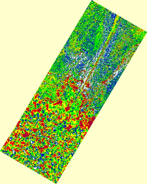
LiDAR-DTM-Difference of Sabangau catchment and CIMTROP Transect between 2007 and 2011. Red legend shows subsidence between 0.3m - 0.4m subsidence, yellow 0.2m - 0.3m and green between 0.1m - 0.2m
Abstract
In August 2007 and 2011 we mapped by helicopter different Peat Swamp Forest (PSF) transactions with Riegl LiDAR Technology (LMS-Q560) and high-resolution Hasselblad camera in Central Kalimantan, Indonesia. Additionally, we collected ground field measurements in order to determine some biophysical properties of different peat swamp forest physiognomies such as diameter at breast height, tree-height, leaf area index, crown coverage and above ground biomass. In this study, our main objectives were: a) to characterize the peat swamp surface in different domes; b) to estimate the dependence of tree canopy height with peat dome slope variations; c) to characterize biophysical properties with peat dome slope and forest physiognomy variations; d) to demonstrate the applicability of LiDAR technology to detect logging activities in dense tropical peat swamp forest environments; and e) to present an approach of change detection based on multi-temporal LiDAR acquisition. Spatial patterns of biophysical property dynamics at a 1-ha scale will be also presented as well as the performance of linear and non-linear methods employed in their retrieval. Pair wise comparisons of nearly coincident LiDAR footprints at the Sabangau transect (e.g. 14km) in the period of four years showed canopy height changes up to 12%. In average, the canopy height increased from 15.32m to 17.18m. This work can be promising in the frame of the REDD+ (Reducing Emissions from Deforestation and forest Degradation) knowledge of tropical PSF. The LiDAR technology supports the MRV aspect of REDD+ (Monitoring, Reporting, Verification).
Keywords: Peat Swamp Forest, LiDAR, ALS, Kalimantan, REDD, MRV
![]()
PSF-CHM for 12km long Sabangau Transect and burnt scar at the end using LiDAR measurements in 2007
