
lidar technologies

Lidar technologies
We measure distances by illuminating a target with a laser and analyze the reflected light.
- Biomass Situation of Mawas Region in Central ...
- Spatial and temporal variation of above ground ...
- Multi-Temporal Airborne LiDAR-Survey and Field ...
- Relating ground field measurements in Indonesian ...
- Assessing Carbon Changes in Peat Swamp Forest ...
- Multi-Temporal Airborne LiDAR-Survey in 2007 and ...
- Characterizing Peat Swamp Forest Environments ...
- Multi-temporal Helicopter LIDAR- and RGB-Survey ...
- Application of LiDAR data for analyzing fires, ...
- LiDAR Technology for peatland using DSM- and ...
- Small-footprint airborne LiDAR technology for ...
- 2006 Fire depth and tree height analysis in Block ...
- Relating tree height variations to peat dome ...
- LiDAR- / Airborne Laser Scanning mapping of ...
- Rungan Sari PCB, Draft Masterplan with LiDAR-DTM ...
- LiDAR Survey of Small Scale Gold Mining near ...
- Airborne Laser Scanning measurements in Central ...
- Peatland Topography of Ex-MRP measured with ...
- Rungan Sari Airborne Laser Scanning 3D-Model and ...
- Peat Dome Measurements in Tropical Peatlands of ...
- Erfolgreiches Pilotprojekt im tropischen ...
- Airborne Laser Scanning monitoring of Ex-MRP area ...
- Successful Helicopter Flight Trials with Airborne ...
- Successful Helicopter Flight Trials with Airborne ...
- OK Osaki Tsuji Boehm, Liesenberg- Appraisal of ...
gallery

image gallery
Find a large collection of images from many years of exploration by kalteng-consultants.
History Borneo - Kalimantan · Excursions to peatland 1996 · Mega Rice Project 1999 · 2004 · 2005 · 2006 · 2007 · 2008 · 2009 · 2010 · 2011 · 2012 · 2013 · 2014 · 2015 · 2016-March · 2016-August ·
lidar-technology
Airborne Laser Scanning monitoring of Ex-MRP area to archive high-resolution topographical Maps of Peatlands in Central Kalimantan, CKPP report, 11-2007
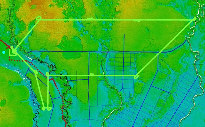
GPS-track of Helicopter Path over Ex-MRP Blocks A, B, C, E on 7.8.2007 on SRTM-image
kalteng KC-Report for CKPP WI 24.11.2007.pdf
poster wi+ckpp als-flight07.08.2007.pdf
by
Viktor Boehm and Juergen Frank
for WI and UNPAR, CKPP
24.11.2007
With a high-resolution Airborne Laser Scanner (ALS) the topography of peatlands was measured in Aug. 2007 by a helicopter to achieve a 3-dimensional Digital Elevation Model (DEM) for the Central Kalimantan Peatland Project (CKPP). The flight altitude was approx. 500m above ground. Approx. 100,000 Laser pulses / second were sending to the ground. With the received ALS-data DEMs were processed.
DEMs are divided into two types of groups. The Digital Surface Model (DSM) gathers information by Laser Scanner with trees, bridges and house and the Digital Terrain Model (DTM) is filtered using the DSM and shows the topography of landscape without trees, bridges, houses etc. With this type of information hydrology models of peatland and biomass of Peat Swamp Forest (PSF) have been analysed using this modern technology with an elevation resolution of +/-15cm e.g. in the Ex-Mega Rice Project (Ex-MRP) area of Blocks A, B, C, E and additionally in the Sebangau National Park.
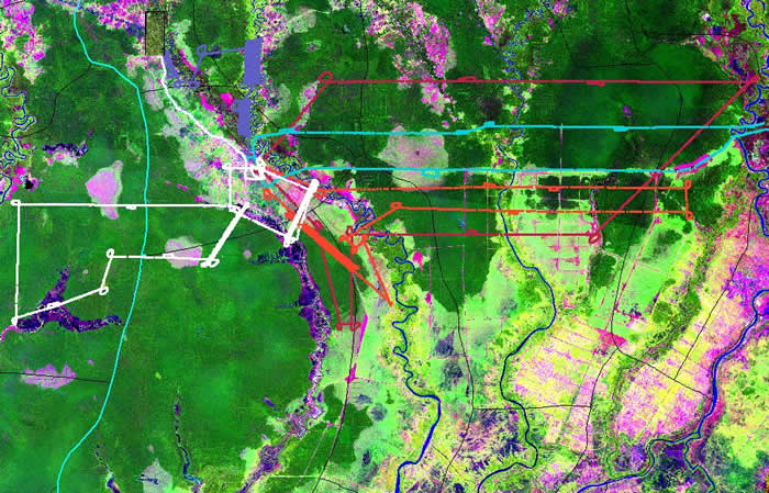
LiDAR Flight Tracks near Palangkaraya, CentralKalimantan, over the Mega Rice Project in Blocks A, B, C + E
