
lidar technologies

Lidar technologies
We measure distances by illuminating a target with a laser and analyze the reflected light.
- Biomass Situation of Mawas Region in Central ...
- Spatial and temporal variation of above ground ...
- Multi-Temporal Airborne LiDAR-Survey and Field ...
- Relating ground field measurements in Indonesian ...
- Assessing Carbon Changes in Peat Swamp Forest ...
- Multi-Temporal Airborne LiDAR-Survey in 2007 and ...
- Characterizing Peat Swamp Forest Environments ...
- Multi-temporal Helicopter LIDAR- and RGB-Survey ...
- Application of LiDAR data for analyzing fires, ...
- LiDAR Technology for peatland using DSM- and ...
- Small-footprint airborne LiDAR technology for ...
- 2006 Fire depth and tree height analysis in Block ...
- Relating tree height variations to peat dome ...
- LiDAR- / Airborne Laser Scanning mapping of ...
- Rungan Sari PCB, Draft Masterplan with LiDAR-DTM ...
- LiDAR Survey of Small Scale Gold Mining near ...
- Airborne Laser Scanning measurements in Central ...
- Peatland Topography of Ex-MRP measured with ...
- Rungan Sari Airborne Laser Scanning 3D-Model and ...
- Peat Dome Measurements in Tropical Peatlands of ...
- Erfolgreiches Pilotprojekt im tropischen ...
- Airborne Laser Scanning monitoring of Ex-MRP area ...
- Successful Helicopter Flight Trials with Airborne ...
- Successful Helicopter Flight Trials with Airborne ...
- OK Osaki Tsuji Boehm, Liesenberg- Appraisal of ...
gallery

image gallery
Find a large collection of images from many years of exploration by kalteng-consultants.
History Borneo - Kalimantan · Excursions to peatland 1996 · Mega Rice Project 1999 · 2004 · 2005 · 2006 · 2007 · 2008 · 2009 · 2010 · 2011 · 2012 · 2013 · 2014 · 2015 · 2016-March · 2016-August ·
lidar-technology
LiDAR- / Airborne Laser Scanning mapping of Barito-Oil area for high-resolution topographic maps in Central Kalimantan; 4-2010
LiDAR- / Airborne Laser Scanning mapping of Barito-Oil area for high-resolution topographic maps in Central Kalimantan
Barito Basin Oil - Active Fault mapping – Sihung structure
by
H.-D. Viktor Boehm,
Kalteng Consultants
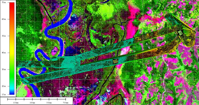
LiDAR-DSM at Barito area supperimposed on Landsat image from 2000

LiDAR-DTM at Barito area with contourlines 2m EL superimposed on LS2000 to find acive fault mapping
