
lidar technologies

Lidar technologies
We measure distances by illuminating a target with a laser and analyze the reflected light.
- Biomass Situation of Mawas Region in Central ...
- Spatial and temporal variation of above ground ...
- Multi-Temporal Airborne LiDAR-Survey and Field ...
- Relating ground field measurements in Indonesian ...
- Assessing Carbon Changes in Peat Swamp Forest ...
- Multi-Temporal Airborne LiDAR-Survey in 2007 and ...
- Characterizing Peat Swamp Forest Environments ...
- Multi-temporal Helicopter LIDAR- and RGB-Survey ...
- Application of LiDAR data for analyzing fires, ...
- LiDAR Technology for peatland using DSM- and ...
- Small-footprint airborne LiDAR technology for ...
- 2006 Fire depth and tree height analysis in Block ...
- Relating tree height variations to peat dome ...
- LiDAR- / Airborne Laser Scanning mapping of ...
- Rungan Sari PCB, Draft Masterplan with LiDAR-DTM ...
- LiDAR Survey of Small Scale Gold Mining near ...
- Airborne Laser Scanning measurements in Central ...
- Peatland Topography of Ex-MRP measured with ...
- Rungan Sari Airborne Laser Scanning 3D-Model and ...
- Peat Dome Measurements in Tropical Peatlands of ...
- Erfolgreiches Pilotprojekt im tropischen ...
- Airborne Laser Scanning monitoring of Ex-MRP area ...
- Successful Helicopter Flight Trials with Airborne ...
- Successful Helicopter Flight Trials with Airborne ...
- OK Osaki Tsuji Boehm, Liesenberg- Appraisal of ...
gallery

image gallery
Find a large collection of images from many years of exploration by kalteng-consultants.
History Borneo - Kalimantan · Excursions to peatland 1996 · Mega Rice Project 1999 · 2004 · 2005 · 2006 · 2007 · 2008 · 2009 · 2010 · 2011 · 2012 · 2013 · 2014 · 2015 · 2016-March · 2016-August ·
lidar-technology
Airborne Laser Scanning measurements in Central Kalimantan of Lake Batu to achieve high-resolution Digital Elevation Models of Tropical Peatlands; 12-2008
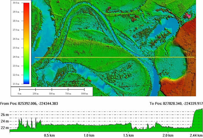
Airborne Laser Scanning Data as DTM without trees and a profil, processed 12-2008
Boehm-KC-ALS-Kahayan Lake Batu-09-12-2008.pdf
Flood Simulation of river Kahayan and Lake Batu north of Palangkaraya
by
Viktor Boehm and Juergen Frank
Viktor Boehm and Juergen Frank
Corrected ALS (geo-coded) raw data are available from several helicopter flights of Sebangau and of Ex-MRP area. The calibration flight track 88 confirmed the 25.0m altitude for PKY airport. Even other flights on other days had the same elevation value of 25.0m for PKY airport.
The calibration flight track 88 confirmed the 25.0m altitude for PKY airport. Even other flights on other days had the same elevation value of 25.0m for PKY airport.
The ALS is penetrating the PSF, which shows the very good results of the DTMs. Manual analysis of the ALS data show a similar result compared to the automatic SW-analysis.
The visualisation of three dimensional data is not so easy and needs specific SW and skills of the operator. Tracks from the ALS flights are available of Sebangau and EX-MRP to be analysed.
Precise ALS-data with +/-0.5m resolution in x and y and +/-0.15m in z (elevation) were recorded
for analysis's of PSF-bio mass estimation, topographical and hydrological.
With the processed DSMs and DTMs the tree height can be determined very quickly by subtraction.
Filtering/Classification was done automatically with manual controls.
The ALS is penetrating the PSF, which shows the very good results of the DTMs.
Manual analysis of the ALS data show a similar result compared to the automatic SW-analysis.
The visualisation of three dimensional data is not so easy and needs specific SW and skills of the operator. Tracks from the ALS flights are available of Sebangau and EX-MRP to be analysed.
The ALS campaign in August 2007 of the Sabangau and Ex-MRP area was a success.
The laser beam in the near infra-red could penetrate the PSF with the divergence of 0.5mrad.
No interrupts of the ALS with 100,000 pulses per second, INS and other measuring devices occurred during the complete all HC-flights. Big Peat Layers are accumulated in Central Kalimantan between the rivers in the low altitude near to the Java Sea with up to 12m thickness (UNPAR) in the Ex-Mega Rice Project (Ex-MRP) and in Sebangau National Park.
A lot of carbon is stored in Central Kalimantan; emission of these carbon will contribute to climate change. Degraded Peatlands without trees are sensitive for burning in the dry season; e.g. 1994, 1997, 2002, 2006.
The water-level should be kept high in the peat area of Sebangau National Park and Ex-MRP by blocking of many channels with different sizes and the area should be replanted with forests, to avoid fires.
The water-level should be kept high in the peat area of Sebangau National Park and Ex-MRP by blocking of many channels with different sizes and the area should be replanted with forests, to avoid fires.
