
remote sensing

our work
kalteng remote sensing shows trends in environments like Kalimantan.
- TanDEM-X elevation model data for canopy height ...
- Monitoring Forest Threats with C- and L-band SAR, ...
- Ground Penetrating Radar Mapping of Peat ...
- Spectral Variability and Discrimination ...
- Kalteng Consultants Company Profile, Oct
- Visiting of Wetlands International Camp on ...
- Ortho Photo Mosaik von Kelurahan Tumbang Tahai ...
- Ortho-Photo Mosaik from Lake Batu, north of ...
- International Symposium & Workshop on Tropical ...
- The Contribution of CHRIS/PROBA Data for Tropical ...
- Workshop on Spatial Planning and new Remote ...
- Ortho-Photo Generation and Mosaiking of City ...
- Ortho-Photo Mosaik from Kecamatan Bukit Batu, ...
- International Workshop, Wild Fire and Carbon ...
- Planning Group for Kecamatan Bukit Batu gathered ...
- Carbon Storage in the Northern Sabangau Area ...
- Peat Land Topography derived from 30m Resolution ...
- Peat depth, minerals below peat, carbon, fires ...
- Carbon Storage in the Northern Sebangau Area ...
- Peatland Topography DEM-measurements with ...
- Precise Measurements of Peatland Topography and ...
- Environmental Management Study of the Tangkiling ...
- Environmental Field Trials and GIS Image ...
- Land Cover Change on Peatland in Kalimantan ...
- The Impact of Logging and Land Use Change in ...
- Tracks along the Kalimantan Highway from Kasongan ...
- Fires in 2002 monitored on the Landsat-images 14 ...
- The Amount of Carbon released from Peat and ...
- Land use Change in Central Kalimantan over the ...
- Remote Sensing and Aerial Survey of Vegetation ...
- Monitoring land cover and impacts, Remote Sensing ...
- Fire Impacts and Carbon Release on Tropical ...
- Ecological Impact of the one Million Hectare Rice ...
- Land Use Change and (Il)-Legal Logging in Central ...
- Peat fires in Central Kalimantan, Indonesia: Fire ...
- Environmental Helicopter Flight Trails with ...
- Impact of the 1997 Fires on the Peatlands of ...
- Application of Remote Sensing and GIS to monitor ...
- Monitoring of 1997/1998 Fires and Burnt Scars in ...
- Flight survey over the Mega Rice Project and over ...
- Application of Remote Sensing and GIS to survey ...
- Mega Rice Project in Central Kalimantan, ...
- Satellite Images and Aerial Photos from the ...
- The need for better
- Remote Sensing Verification by Aerial Surveys and ...
- NATURAL RESOURCE FUNCTIONS, BIODIVERSITY AND ...
- Excursion to Central Kalimantan, ...
- Satellite Images and Aerial Photography’s from ...
- Symposium of International Peat Society, ...
- Indonesia Travel to Jakarta, Bali and Kalimantan ...
- The Mega Rice Project Central Kalimantan ...
- Land Use Planning and Environmental Monitoring in ...
- Bildverarbeitung von Sensorbildern zur Erstellung ...
- GIS-Workshop, Camp km48 Sangai.
- Monitoring Land Use Change on Tropical Peatland ...
- Seminar on Scientific Implications of the ...
- Report of Ground Truth Campaigns incl. Aerial ...
- Ground and Helicopter verification of Satellite ...
- Environmental Detection from Satellite and ...
- First visit to Central Kalimantan in June 1995, ...
- Environmental Helicopter with Modular Sensor ...
- Remote Sensing with a Thermal Imager on an ...
- The Use of an Environmental Helicopter for the ...
- EUROMAR-SEASTARS a Modular Multi-Sensor System ...
gallery

image gallery
Find a large collection of images from many years of exploration by kalteng-consultants.
History Borneo - Kalimantan · Excursions to peatland 1996 · Mega Rice Project 1999 · 2004 · 2005 · 2006 · 2007 · 2008 · 2009 · 2010 · 2011 · 2012 · 2013 · 2014 · 2015 · 2016-March · 2016-August ·
remote sensing
Excursion to Central Kalimantan, MAF-Cessna-Flight on 3.11.1998
Excursion over MRP, Tangkiling area and Sabangau area with Florian, Adi and Viktor
Sa.31.10.1998: Kalampangan, Garung-canel drive
Su.01.11.1998: Habaring Hurung Transmigration, PSF, logger, Rungan Sari, Transmigration km29.5
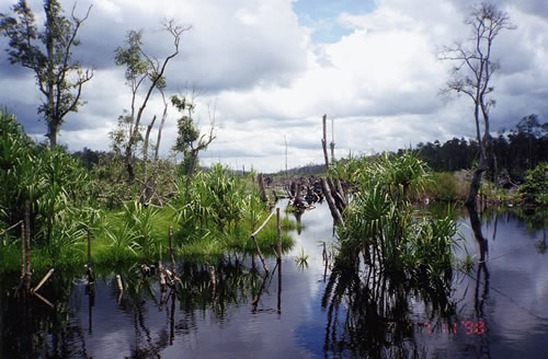
Mo.02.11.1998: River Tilap into direction of Takaras, 10km Boats drive, heath forest
Tu 03.11.1998: MAF-Cessna flight over Sabangau area,Tangkiling hills and MRP with main channel, Mentangai
and Block A, Lamunti, Garung
We04.11.1998: Berenbengkel, Kahayan-sluice, Boats-Tour along the main channel, dams
Th05.11.1998: Three days trip: Pulau Pisang, Pangkoh9, Anjir Basarang, Kuala Kapuas
Fr.06.11.1998: Palingau Lama, Dadahup, with motor-bikes to Lamunti, Kapuas up to village Mentangai
Sa.07.11.1998: Boats-tour Mentangai river up to Main Channel, back, speedboat to Mandomai, back PKY
Mo.09.11.1998: Kijang-Drive to Bukit Liti and to the Mangatup river, from Bukit Raya with boat tp PKY
Tu.10.11.1998: DARTROP-Workshop im Dandang Tingan
We.11.11.1998: EUTROP-Workshop im Dandang Tingan
Th.12.11.1998: Tour to Camp Setia Alam Jaya, CIMTROP near to Sabangau Catchment
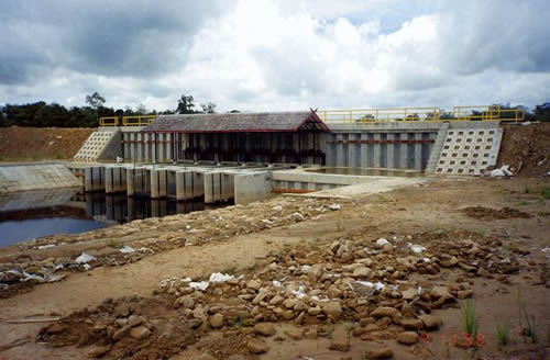
Main channel of MRP with sluices; 4.11.1998
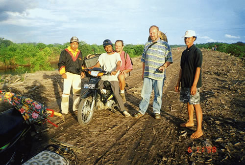
MRP, Block A, Florian + Viktor motor-bike drive near Dadahup on peatland; 6.11.1998

Mentangai river, Florian, Viktor; 7.11.1998

Mentangai river with burnt trees, 7.11.1998
Mentangai crossing Main Channel; 7.11.1998

Mentangai river, boat defect; 7.11.1998

Main channel, 3.11.1998

Main channel of MRP with burnt PSF; 3.11.1998
Mentangai river with burnt trees, 7.11.1998
Mentangai crossing Main Channel; 7.11.1998
Mentangai river, boat defect; 7.11.1998
Main channel, 3.11.1998
Main channel of MRP with burnt PSF; 3.11.1998
