
remote sensing

our work
kalteng remote sensing shows trends in environments like Kalimantan.
- TanDEM-X elevation model data for canopy height ...
- Monitoring Forest Threats with C- and L-band SAR, ...
- Ground Penetrating Radar Mapping of Peat ...
- Spectral Variability and Discrimination ...
- Kalteng Consultants Company Profile, Oct
- Visiting of Wetlands International Camp on ...
- Ortho Photo Mosaik von Kelurahan Tumbang Tahai ...
- Ortho-Photo Mosaik from Lake Batu, north of ...
- International Symposium & Workshop on Tropical ...
- The Contribution of CHRIS/PROBA Data for Tropical ...
- Workshop on Spatial Planning and new Remote ...
- Ortho-Photo Generation and Mosaiking of City ...
- Ortho-Photo Mosaik from Kecamatan Bukit Batu, ...
- International Workshop, Wild Fire and Carbon ...
- Planning Group for Kecamatan Bukit Batu gathered ...
- Carbon Storage in the Northern Sabangau Area ...
- Peat Land Topography derived from 30m Resolution ...
- Peat depth, minerals below peat, carbon, fires ...
- Carbon Storage in the Northern Sebangau Area ...
- Peatland Topography DEM-measurements with ...
- Precise Measurements of Peatland Topography and ...
- Environmental Management Study of the Tangkiling ...
- Environmental Field Trials and GIS Image ...
- Land Cover Change on Peatland in Kalimantan ...
- The Impact of Logging and Land Use Change in ...
- Tracks along the Kalimantan Highway from Kasongan ...
- Fires in 2002 monitored on the Landsat-images 14 ...
- The Amount of Carbon released from Peat and ...
- Land use Change in Central Kalimantan over the ...
- Remote Sensing and Aerial Survey of Vegetation ...
- Monitoring land cover and impacts, Remote Sensing ...
- Fire Impacts and Carbon Release on Tropical ...
- Ecological Impact of the one Million Hectare Rice ...
- Land Use Change and (Il)-Legal Logging in Central ...
- Peat fires in Central Kalimantan, Indonesia: Fire ...
- Environmental Helicopter Flight Trails with ...
- Impact of the 1997 Fires on the Peatlands of ...
- Application of Remote Sensing and GIS to monitor ...
- Monitoring of 1997/1998 Fires and Burnt Scars in ...
- Flight survey over the Mega Rice Project and over ...
- Application of Remote Sensing and GIS to survey ...
- Mega Rice Project in Central Kalimantan, ...
- Satellite Images and Aerial Photos from the ...
- The need for better
- Remote Sensing Verification by Aerial Surveys and ...
- NATURAL RESOURCE FUNCTIONS, BIODIVERSITY AND ...
- Excursion to Central Kalimantan, ...
- Satellite Images and Aerial Photography’s from ...
- Symposium of International Peat Society, ...
- Indonesia Travel to Jakarta, Bali and Kalimantan ...
- The Mega Rice Project Central Kalimantan ...
- Land Use Planning and Environmental Monitoring in ...
- Bildverarbeitung von Sensorbildern zur Erstellung ...
- GIS-Workshop, Camp km48 Sangai.
- Monitoring Land Use Change on Tropical Peatland ...
- Seminar on Scientific Implications of the ...
- Report of Ground Truth Campaigns incl. Aerial ...
- Ground and Helicopter verification of Satellite ...
- Environmental Detection from Satellite and ...
- First visit to Central Kalimantan in June 1995, ...
- Environmental Helicopter with Modular Sensor ...
- Remote Sensing with a Thermal Imager on an ...
- The Use of an Environmental Helicopter for the ...
- EUROMAR-SEASTARS a Modular Multi-Sensor System ...
gallery

image gallery
Find a large collection of images from many years of exploration by kalteng-consultants.
History Borneo - Kalimantan · Excursions to peatland 1996 · Mega Rice Project 1999 · 2004 · 2005 · 2006 · 2007 · 2008 · 2009 · 2010 · 2011 · 2012 · 2013 · 2014 · 2015 · 2016-March · 2016-August ·
remote sensing
Environmental Management Study of the Tangkiling District along River Rungan in Central Kalimantan, using Remote Sensing and GIS; 9-2005
presented at
in Yogyakarta, Indonesia, 27-29 Sept 2005 by
a) Kalteng Consultants, Germany + Indonesia
b) Universidade Tecnologica de Pereira, Colombia, Carrera
c) Jalan Tjilik Riwut km36, Rungan-Sari, Palangkaraya, 73225, Indonesia
Abstract
Vast areas of peat swamp forest (PSF) cover the coastal plains of Central Kalimantan from the Java Sea up to the provincial capital of Palangkaraya and further North. PSF is among the earth's most endangered ecosystem, with a huge carbon storage capacity ref.7+10, extremely fragile to disturbance. Landsat ETM images 118-61+62, acquired on 14.Jan/15.Feb2003, were compared by using detailed analysis of the region around the Tangkiling granite hills and the black water river Rungan north of Palangkaraya.
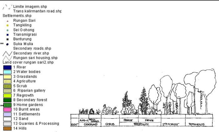
These images show major changes in this largest remnant of tropical peatland related to extreme rates of deforestation and fires in 2002, since 1997, compared to older Landsat images from 1991/1997/2000, ref.3+4. With the establishment of the Mega Rice Project (MRP) and the infrastructures of roads, many people were able to enter the previously inaccessible interior of this peatland landscape, exploit residual timber resources, mostly on an illegal basis, and using fire for land clearance as the most economical method. Ground truthing were done in this study area in 2004. We analyzed several maps around the Tangkiling hills, Sei Gohong and Rungan-Sari with areas of PSF, grassland, agriculture, scrub, riparian gallery, regrowth, secondary forest, home gardens, burnt areas from 2002, settlement, sand, water bodies etc.
We formulate and prioritize strategies of the area trying to combine needs of conservation and needs of local people to recover biodiversity and improve the land situation. The minor el Nino of 2002 in that region led to human health problems, although somewhat less serious than in 1997. Previous legal logging prepared the ground for further degradation of forests by fire and illegal logging. If this situation continues there is a high risk of most PSF of Central Kalimantan being destroyed within a few years. This would have grave consequences for the local hydrology, climate, biodiversity and livelihood of local population. Keywords: Central-Kalimantan, Tropical-Peatland PSF, Conservation, Environmental Management, Fires 2002, Remote Sensing/GIS, Landsat, GPS, Tangkiling/Sei Gohong/Rungan-Sari
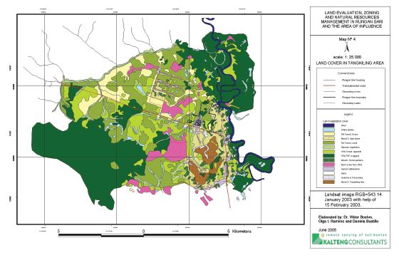
Land Cover Map from Tangkiling, Bukit Batu
