
remote sensing

our work
kalteng remote sensing shows trends in environments like Kalimantan.
- TanDEM-X elevation model data for canopy height ...
- Monitoring Forest Threats with C- and L-band SAR, ...
- Ground Penetrating Radar Mapping of Peat ...
- Spectral Variability and Discrimination ...
- Kalteng Consultants Company Profile, Oct
- Visiting of Wetlands International Camp on ...
- Ortho Photo Mosaik von Kelurahan Tumbang Tahai ...
- Ortho-Photo Mosaik from Lake Batu, north of ...
- International Symposium & Workshop on Tropical ...
- The Contribution of CHRIS/PROBA Data for Tropical ...
- Workshop on Spatial Planning and new Remote ...
- Ortho-Photo Generation and Mosaiking of City ...
- Ortho-Photo Mosaik from Kecamatan Bukit Batu, ...
- International Workshop, Wild Fire and Carbon ...
- Planning Group for Kecamatan Bukit Batu gathered ...
- Carbon Storage in the Northern Sabangau Area ...
- Peat Land Topography derived from 30m Resolution ...
- Peat depth, minerals below peat, carbon, fires ...
- Carbon Storage in the Northern Sebangau Area ...
- Peatland Topography DEM-measurements with ...
- Precise Measurements of Peatland Topography and ...
- Environmental Management Study of the Tangkiling ...
- Environmental Field Trials and GIS Image ...
- Land Cover Change on Peatland in Kalimantan ...
- The Impact of Logging and Land Use Change in ...
- Tracks along the Kalimantan Highway from Kasongan ...
- Fires in 2002 monitored on the Landsat-images 14 ...
- The Amount of Carbon released from Peat and ...
- Land use Change in Central Kalimantan over the ...
- Remote Sensing and Aerial Survey of Vegetation ...
- Monitoring land cover and impacts, Remote Sensing ...
- Fire Impacts and Carbon Release on Tropical ...
- Ecological Impact of the one Million Hectare Rice ...
- Land Use Change and (Il)-Legal Logging in Central ...
- Peat fires in Central Kalimantan, Indonesia: Fire ...
- Environmental Helicopter Flight Trails with ...
- Impact of the 1997 Fires on the Peatlands of ...
- Application of Remote Sensing and GIS to monitor ...
- Monitoring of 1997/1998 Fires and Burnt Scars in ...
- Flight survey over the Mega Rice Project and over ...
- Application of Remote Sensing and GIS to survey ...
- Mega Rice Project in Central Kalimantan, ...
- Satellite Images and Aerial Photos from the ...
- The need for better
- Remote Sensing Verification by Aerial Surveys and ...
- NATURAL RESOURCE FUNCTIONS, BIODIVERSITY AND ...
- Excursion to Central Kalimantan, ...
- Satellite Images and Aerial Photography’s from ...
- Symposium of International Peat Society, ...
- Indonesia Travel to Jakarta, Bali and Kalimantan ...
- The Mega Rice Project Central Kalimantan ...
- Land Use Planning and Environmental Monitoring in ...
- Bildverarbeitung von Sensorbildern zur Erstellung ...
- GIS-Workshop, Camp km48 Sangai.
- Monitoring Land Use Change on Tropical Peatland ...
- Seminar on Scientific Implications of the ...
- Report of Ground Truth Campaigns incl. Aerial ...
- Ground and Helicopter verification of Satellite ...
- Environmental Detection from Satellite and ...
- First visit to Central Kalimantan in June 1995, ...
- Environmental Helicopter with Modular Sensor ...
- Remote Sensing with a Thermal Imager on an ...
- The Use of an Environmental Helicopter for the ...
- EUROMAR-SEASTARS a Modular Multi-Sensor System ...
gallery

image gallery
Find a large collection of images from many years of exploration by kalteng-consultants.
History Borneo - Kalimantan · Excursions to peatland 1996 · Mega Rice Project 1999 · 2004 · 2005 · 2006 · 2007 · 2008 · 2009 · 2010 · 2011 · 2012 · 2013 · 2014 · 2015 · 2016-March · 2016-August ·
remote sensing
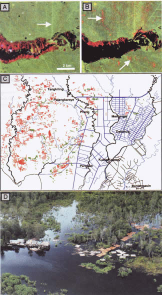
The Impact of Logging and Land Use Change in Central Kalimantan, Indonesia, published in IPS 2004, No.12
Detection of logging operation
published
in International Peat Journal of IPS, 2004, No.12, pp. 3-10
kalteng 2004-International Peat Society Number 12.pdf
1) Kalteng Consultants,
Kirchstockacher Weg 2, D-85635 Hoehenkirchen, Germany, E-mail: viktorboehm@t-online.de
2) Ludwig-Maximilians-Universität München, Biology Department II, Luisenstr. 14,
D-80333 München & Remote Sensing Solutions GmbH, Worthstr. 49, D-81667 Munchen, Germany
The province of Central Kalimantan contains about three million hectares of peatland, which is one of the larg¬est contiguous areas of tropical peatland in the world. Peat Swamp Forests (PSF) are among the earth's most endangered and least known ecosystems. They have a huge carbon storage capacity but are extremely fragile and liable to disturbance. Local communities have used them extensively for centuries without significant impact on the environment. This changed in 1995 when a programme of massive peatland conversion, the so-called Mega Rice Project (MRP), was initiated with the aim of converting one million hectares of peatland, in Central Kalimantan, Indonesia, into rice fields. Between 1996 and 1998 more than 4000 km of drainage and irrigation channels were constructed in the designated area. Boosted by the El Nino Southern Oscillation (ENSO) episode in 1997, many fires initiated for land clearance purposes spread into pristine forest areas where they continued to burn with great intensity.
The newly established drainage and irrigation system aggravated fire impacts, fostering this disaster. The multi-temporal analysis of six LANDSAT TM images acquired between 1991 and 2000 shows extremely high rates of deforestation during this time. Between 1991 and 2000 the area of forest was reduced at the rate of 3.2% per year. If the situation continues there is a very high risk that most of the peat swamp forest resource in Central Kalimantan will be destroyed within a few years with grave consequences for the hydrology, local climate, biodiversity and livelihood of local people. Unless land use policies are changed to control logging and the drainage of the peatland is stopped recurrent fires will lead to an irrecoverable loss of this unique rainforest ecosystem and release of huge amounts of carbon to the atmosphere. Keywords: logging, remote sensing, GIS, land use, deforestation, tropical rainforest, peat swamp forest, Kalimantan, Borneo
