
remote sensing

our work
kalteng remote sensing shows trends in environments like Kalimantan.
- TanDEM-X elevation model data for canopy height ...
- Monitoring Forest Threats with C- and L-band SAR, ...
- Ground Penetrating Radar Mapping of Peat ...
- Spectral Variability and Discrimination ...
- Kalteng Consultants Company Profile, Oct
- Visiting of Wetlands International Camp on ...
- Ortho Photo Mosaik von Kelurahan Tumbang Tahai ...
- Ortho-Photo Mosaik from Lake Batu, north of ...
- International Symposium & Workshop on Tropical ...
- The Contribution of CHRIS/PROBA Data for Tropical ...
- Workshop on Spatial Planning and new Remote ...
- Ortho-Photo Generation and Mosaiking of City ...
- Ortho-Photo Mosaik from Kecamatan Bukit Batu, ...
- International Workshop, Wild Fire and Carbon ...
- Planning Group for Kecamatan Bukit Batu gathered ...
- Carbon Storage in the Northern Sabangau Area ...
- Peat Land Topography derived from 30m Resolution ...
- Peat depth, minerals below peat, carbon, fires ...
- Carbon Storage in the Northern Sebangau Area ...
- Peatland Topography DEM-measurements with ...
- Precise Measurements of Peatland Topography and ...
- Environmental Management Study of the Tangkiling ...
- Environmental Field Trials and GIS Image ...
- Land Cover Change on Peatland in Kalimantan ...
- The Impact of Logging and Land Use Change in ...
- Tracks along the Kalimantan Highway from Kasongan ...
- Fires in 2002 monitored on the Landsat-images 14 ...
- The Amount of Carbon released from Peat and ...
- Land use Change in Central Kalimantan over the ...
- Remote Sensing and Aerial Survey of Vegetation ...
- Monitoring land cover and impacts, Remote Sensing ...
- Fire Impacts and Carbon Release on Tropical ...
- Ecological Impact of the one Million Hectare Rice ...
- Land Use Change and (Il)-Legal Logging in Central ...
- Peat fires in Central Kalimantan, Indonesia: Fire ...
- Environmental Helicopter Flight Trails with ...
- Impact of the 1997 Fires on the Peatlands of ...
- Application of Remote Sensing and GIS to monitor ...
- Monitoring of 1997/1998 Fires and Burnt Scars in ...
- Flight survey over the Mega Rice Project and over ...
- Application of Remote Sensing and GIS to survey ...
- Mega Rice Project in Central Kalimantan, ...
- Satellite Images and Aerial Photos from the ...
- The need for better
- Remote Sensing Verification by Aerial Surveys and ...
- NATURAL RESOURCE FUNCTIONS, BIODIVERSITY AND ...
- Excursion to Central Kalimantan, ...
- Satellite Images and Aerial Photography’s from ...
- Symposium of International Peat Society, ...
- Indonesia Travel to Jakarta, Bali and Kalimantan ...
- The Mega Rice Project Central Kalimantan ...
- Land Use Planning and Environmental Monitoring in ...
- Bildverarbeitung von Sensorbildern zur Erstellung ...
- GIS-Workshop, Camp km48 Sangai.
- Monitoring Land Use Change on Tropical Peatland ...
- Seminar on Scientific Implications of the ...
- Report of Ground Truth Campaigns incl. Aerial ...
- Ground and Helicopter verification of Satellite ...
- Environmental Detection from Satellite and ...
- First visit to Central Kalimantan in June 1995, ...
- Environmental Helicopter with Modular Sensor ...
- Remote Sensing with a Thermal Imager on an ...
- The Use of an Environmental Helicopter for the ...
- EUROMAR-SEASTARS a Modular Multi-Sensor System ...
gallery

image gallery
Find a large collection of images from many years of exploration by kalteng-consultants.
History Borneo - Kalimantan · Excursions to peatland 1996 · Mega Rice Project 1999 · 2004 · 2005 · 2006 · 2007 · 2008 · 2009 · 2010 · 2011 · 2012 · 2013 · 2014 · 2015 · 2016-March · 2016-August ·
remote sensing
Planning Group for Kecamatan Bukit Batu gathered at Kalimantan Visioning Workshop, 15-17 March 2008
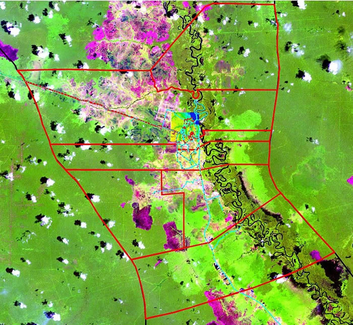
Kecamatan Bukit Batu with seven Kelurahan´s on Landsat image from 2003
Kanarakan, - Sei Gohong, - Tangkiling, - Banturung, - Habaring Hurung, - Tumbang Tahai, - Marang
Connecting Government and Community through Innovative Local Planning: A Pilot to Strengthen Local Development in Bukit Batu Draft Context Indonesia’s transition to democracy over the past ten years has been marked by broad changes in the concept of government and community. A once centralized government has now been replaced by a decentralised system of governance where villagers are now recognized as citizens with rights and where participation is a stated principle of development. This wholesale and on-going reform of Indonesia’s system of government has begun to take root and deliver benefits but unevenly across the country. Central Kalimantan is Indonesia’s fourth largest province, rich in natural resources but with obvious poverty, especially in the province’s extensive peat and remote areas.
To date, Central Kalimantan has been considered a low priority for international donors but more recently, with global interest in climate change and Reducing Emissions from Deforestation in Development (REDD) countries, the province has become a focus of donor attention. This proposal aims to pilot an innovative approach to local development that builds on existing reforms and extend these through a pilot project in the sub-district of Bukit Batu, Palangkaraya district in Central Kalimantan. Its success will have potential for up scaling to areas beyond Bukit Batu in what is seen as a key province in Indonesia. Concept Local development is known to depend highly on the institutions and capacity of the government and the society. Institution and capacity building is seen as a key means of putting in place the necessary basis for long-term development.
The process of planning, which like development depends on strong institutions, provides the starting point for local development. Poor development plans that do not accurately reflect reality or the priority of people living in an area are guaranteed to generate future problems and fail. Within this context, an effective plan is a springboard for the future. Indonesia has three main mechanisms for the planning of local development:
- Formal government development planning (and associated budgeting of services and programs) as governed by Law No 25/2004:
- Community planning, formally by government through the Musrenbang, and informally by NGOs and other interested parties; by YTS
- Spatial planning as governed by Law 26/2007 by Kalteng Consultants
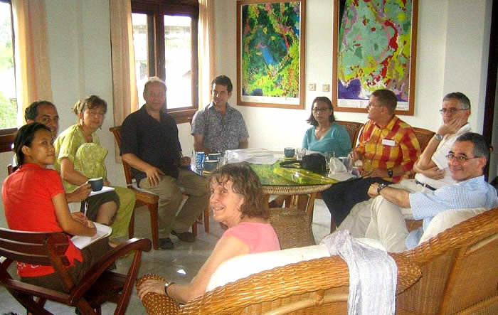
Kick-off meeting of Spatial Planing Group on 16.03.2008 in KC Rungan Sari office.
