
remote sensing

our work
kalteng remote sensing shows trends in environments like Kalimantan.
- TanDEM-X elevation model data for canopy height ...
- Monitoring Forest Threats with C- and L-band SAR, ...
- Ground Penetrating Radar Mapping of Peat ...
- Spectral Variability and Discrimination ...
- Kalteng Consultants Company Profile, Oct
- Visiting of Wetlands International Camp on ...
- Ortho Photo Mosaik von Kelurahan Tumbang Tahai ...
- Ortho-Photo Mosaik from Lake Batu, north of ...
- International Symposium & Workshop on Tropical ...
- The Contribution of CHRIS/PROBA Data for Tropical ...
- Workshop on Spatial Planning and new Remote ...
- Ortho-Photo Generation and Mosaiking of City ...
- Ortho-Photo Mosaik from Kecamatan Bukit Batu, ...
- International Workshop, Wild Fire and Carbon ...
- Planning Group for Kecamatan Bukit Batu gathered ...
- Carbon Storage in the Northern Sabangau Area ...
- Peat Land Topography derived from 30m Resolution ...
- Peat depth, minerals below peat, carbon, fires ...
- Carbon Storage in the Northern Sebangau Area ...
- Peatland Topography DEM-measurements with ...
- Precise Measurements of Peatland Topography and ...
- Environmental Management Study of the Tangkiling ...
- Environmental Field Trials and GIS Image ...
- Land Cover Change on Peatland in Kalimantan ...
- The Impact of Logging and Land Use Change in ...
- Tracks along the Kalimantan Highway from Kasongan ...
- Fires in 2002 monitored on the Landsat-images 14 ...
- The Amount of Carbon released from Peat and ...
- Land use Change in Central Kalimantan over the ...
- Remote Sensing and Aerial Survey of Vegetation ...
- Monitoring land cover and impacts, Remote Sensing ...
- Fire Impacts and Carbon Release on Tropical ...
- Ecological Impact of the one Million Hectare Rice ...
- Land Use Change and (Il)-Legal Logging in Central ...
- Peat fires in Central Kalimantan, Indonesia: Fire ...
- Environmental Helicopter Flight Trails with ...
- Impact of the 1997 Fires on the Peatlands of ...
- Application of Remote Sensing and GIS to monitor ...
- Monitoring of 1997/1998 Fires and Burnt Scars in ...
- Flight survey over the Mega Rice Project and over ...
- Application of Remote Sensing and GIS to survey ...
- Mega Rice Project in Central Kalimantan, ...
- Satellite Images and Aerial Photos from the ...
- The need for better
- Remote Sensing Verification by Aerial Surveys and ...
- NATURAL RESOURCE FUNCTIONS, BIODIVERSITY AND ...
- Excursion to Central Kalimantan, ...
- Satellite Images and Aerial Photography’s from ...
- Symposium of International Peat Society, ...
- Indonesia Travel to Jakarta, Bali and Kalimantan ...
- The Mega Rice Project Central Kalimantan ...
- Land Use Planning and Environmental Monitoring in ...
- Bildverarbeitung von Sensorbildern zur Erstellung ...
- GIS-Workshop, Camp km48 Sangai.
- Monitoring Land Use Change on Tropical Peatland ...
- Seminar on Scientific Implications of the ...
- Report of Ground Truth Campaigns incl. Aerial ...
- Ground and Helicopter verification of Satellite ...
- Environmental Detection from Satellite and ...
- First visit to Central Kalimantan in June 1995, ...
- Environmental Helicopter with Modular Sensor ...
- Remote Sensing with a Thermal Imager on an ...
- The Use of an Environmental Helicopter for the ...
- EUROMAR-SEASTARS a Modular Multi-Sensor System ...
gallery

image gallery
Find a large collection of images from many years of exploration by kalteng-consultants.
History Borneo - Kalimantan · Excursions to peatland 1996 · Mega Rice Project 1999 · 2004 · 2005 · 2006 · 2007 · 2008 · 2009 · 2010 · 2011 · 2012 · 2013 · 2014 · 2015 · 2016-March · 2016-August ·
remote sensing
Peat Land Topography derived from 30m Resolution SRTM-X-SAR Satellite Images for Sebangau Catchment and Kahayan Area at Kalampangan, Central Kalimantan, 9-2006
presented atLIPI-JSPS Core University Program "International Symposium on Nature and Land Management of Tropical Peatland in South East Asia",
Dr. H.-D.V. Boehm 1), Dr. J. Jauhiainen 2), S. Limin 3)
1) Kalteng Consultants, Germany.
2) University of Helsinki, Finland.
3) CIMTROP and UNPAR, Palangka Raya, Indonesia
Keywords: Peat Land Topography, Peat Drilling, Carbon Storage, Sebangau, Fires, SRTM-DEM-X-SAR
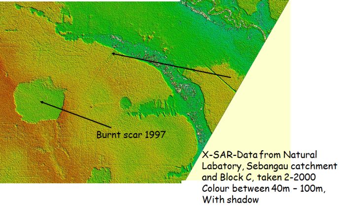
with 30m x 30m resolution
Tropical Peatland has been accumulated between the Rivers Kahayan, Sebangau and Katingan in Central Kalimantan during the last 10 000 years. Since the 1980s peatland and Peat Swamp Forest (PSF) is being opened by selective and illegal logging and destroyed by fires. Before then access to that area of peatland was possible only by boat. Since 1996 the Mega Rice Project (MRP) has inserted irrigation channels into the Block C and destroyed pristine PSF. Partly development took place by human settlements, agricultural cultivation and plantations, which have greatly increased the risk of peatland fires during the dry season. In 1997 and 2002 El Niño prolonged the dry season considerably causing additional risk of fire. With the help of Remote Sensing (RS) and a Geographical Information System (GIS) exact survey is possible, providing information as to the changes in the landscapes and the condition of the environment. An integrate planning and management program can be achieved.
With the help of Landsat and SRTM DEM-X-SAR Satellite images (Shuttle Radar Topography Mission, Digital Elevation Model, Synthetic Aperture Radar) of 30m resolution in x and y and 5m in z-direction the topography of that area have been analysed from which the hydrology and carbon storage and emission situation can be estimated. Results of the peat depth combined with measured minerals below peat and its characteristics will be presented during the workshop and the estimation of carbon storage of that area.
