
remote sensing

our work
kalteng remote sensing shows trends in environments like Kalimantan.
- TanDEM-X elevation model data for canopy height ...
- Monitoring Forest Threats with C- and L-band SAR, ...
- Ground Penetrating Radar Mapping of Peat ...
- Spectral Variability and Discrimination ...
- Kalteng Consultants Company Profile, Oct
- Visiting of Wetlands International Camp on ...
- Ortho Photo Mosaik von Kelurahan Tumbang Tahai ...
- Ortho-Photo Mosaik from Lake Batu, north of ...
- International Symposium & Workshop on Tropical ...
- The Contribution of CHRIS/PROBA Data for Tropical ...
- Workshop on Spatial Planning and new Remote ...
- Ortho-Photo Generation and Mosaiking of City ...
- Ortho-Photo Mosaik from Kecamatan Bukit Batu, ...
- International Workshop, Wild Fire and Carbon ...
- Planning Group for Kecamatan Bukit Batu gathered ...
- Carbon Storage in the Northern Sabangau Area ...
- Peat Land Topography derived from 30m Resolution ...
- Peat depth, minerals below peat, carbon, fires ...
- Carbon Storage in the Northern Sebangau Area ...
- Peatland Topography DEM-measurements with ...
- Precise Measurements of Peatland Topography and ...
- Environmental Management Study of the Tangkiling ...
- Environmental Field Trials and GIS Image ...
- Land Cover Change on Peatland in Kalimantan ...
- The Impact of Logging and Land Use Change in ...
- Tracks along the Kalimantan Highway from Kasongan ...
- Fires in 2002 monitored on the Landsat-images 14 ...
- The Amount of Carbon released from Peat and ...
- Land use Change in Central Kalimantan over the ...
- Remote Sensing and Aerial Survey of Vegetation ...
- Monitoring land cover and impacts, Remote Sensing ...
- Fire Impacts and Carbon Release on Tropical ...
- Ecological Impact of the one Million Hectare Rice ...
- Land Use Change and (Il)-Legal Logging in Central ...
- Peat fires in Central Kalimantan, Indonesia: Fire ...
- Environmental Helicopter Flight Trails with ...
- Impact of the 1997 Fires on the Peatlands of ...
- Application of Remote Sensing and GIS to monitor ...
- Monitoring of 1997/1998 Fires and Burnt Scars in ...
- Flight survey over the Mega Rice Project and over ...
- Application of Remote Sensing and GIS to survey ...
- Mega Rice Project in Central Kalimantan, ...
- Satellite Images and Aerial Photos from the ...
- The need for better
- Remote Sensing Verification by Aerial Surveys and ...
- NATURAL RESOURCE FUNCTIONS, BIODIVERSITY AND ...
- Excursion to Central Kalimantan, ...
- Satellite Images and Aerial Photography’s from ...
- Symposium of International Peat Society, ...
- Indonesia Travel to Jakarta, Bali and Kalimantan ...
- The Mega Rice Project Central Kalimantan ...
- Land Use Planning and Environmental Monitoring in ...
- Bildverarbeitung von Sensorbildern zur Erstellung ...
- GIS-Workshop, Camp km48 Sangai.
- Monitoring Land Use Change on Tropical Peatland ...
- Seminar on Scientific Implications of the ...
- Report of Ground Truth Campaigns incl. Aerial ...
- Ground and Helicopter verification of Satellite ...
- Environmental Detection from Satellite and ...
- First visit to Central Kalimantan in June 1995, ...
- Environmental Helicopter with Modular Sensor ...
- Remote Sensing with a Thermal Imager on an ...
- The Use of an Environmental Helicopter for the ...
- EUROMAR-SEASTARS a Modular Multi-Sensor System ...
gallery

image gallery
Find a large collection of images from many years of exploration by kalteng-consultants.
History Borneo - Kalimantan · Excursions to peatland 1996 · Mega Rice Project 1999 · 2004 · 2005 · 2006 · 2007 · 2008 · 2009 · 2010 · 2011 · 2012 · 2013 · 2014 · 2015 · 2016-March · 2016-August ·
remote sensing
Satellite Images and Aerial Photos from the Tropical Peat Swamp Forest in Central Kalimantan - Analysis of the 1997 Fire Disaster; 6-1999
Poster for IGARSS Conference in Hamburg, Germany, 28.6.-2.7. 1999
kalteng_1999-6-IGARSS-Boehm_Poster1_1.pdf
by
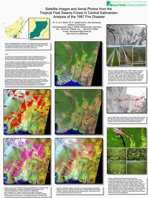
The total area of impact is 1.4 million hectares for the Blocks A, B, C, D and E. The project faces problems of peat domes with a height up to 10m between the main rivers. Satellite-images of the heavy forest fires in Autumn 1997 in Central Kalimantan has been processed too. To undertake global monitoring/survey in a short time, it was essential to use LANDSAT Thematic Mapper, SPOT and ERS1/2 Radar images, linked to a programme of field checking of forest, peatland development and peat condition. Remote sensing technology was used for all survey, monitoring and planning tasks. This paper presents some of the results from LANDSAT, ERS1 and ERS2 image processing activities from aerial surveys on 13 and 27 June 1998, as well as from several ground truth campaigns in 1997 and 1998 (compare ref. 2 Kalteng report from 1996). Further evaluation will take place in the next three years (1999 - 2001) within the framework of a European Union project with 6 international partners: Natural Resource Functions, Biodiversity and Sustainable Management of Tropical Peatlands.
Figure 1: Kalimantan/Borneo, Indonesia. The magnified section shows part of the Central Kalimantan province that was allocated for the Mega Rice Project. The project was divided into five work stages: block A, B, C, D and E. P indicates the remaining pristine peat swamp forest area.
Figure 2: Irrigation channels of the 1 Million hectare rice project. A: Gamma map filtered ERS-image mosaic showing irrigation Channels (PPC, MPC, SC, TC) of the "Mega-Rice-Project" at the river Kapuas region. (ERS images acquired 18 Sept 1997 and 2 Sept 1997) Aerial Photos B: Main Channel, 110 km long, C: Side channel filled with water near Kapuas river, D: Dried out side channel in the centre of the peat dome between Kahayan and Kapuas river. Burnt scars are visible along the channels.
Figure 3: ERS-image mosaic taken on 2 and 18 Sept 1997, showing 1.1 the Mega-Rice Project Area with Parent Primary Channel between Kapuas and Barito and NOAA AVHRR Hot-Spots from acquired between January and April 1998 by IFFM (GTZ), Samarinda
Figure 4 (top picture): LANDSAT-TM image (RGB=543) from 29 March 1998 of Central Kalimantan, showing the Mega Rice Project after the fires. Three level classification of burnt scars of the 1997/98 fires. (red = severe burns, orange = medium burns, yellow = low burns)
Figure 5 (bottom picture): Fire hot spots taken from ATRS (ERS) Satellite showing same area as Figure 4, in the period of August to November 1997.
Figure 6: LANDSAT images (118-62) from Central Kalimantan with RGB¬bands 543 res. 542 from 30 June 1991 (top), 29 May 1997 before the fires (middle), 29 March 1998 after the fires (lower picture). Heavy burnt scam can be monitored (compare with Figure 4).
Figure 7: Different peat swamp forest types (P.S.F.). A: LANDSAT-TM image (118-62, 10 May 1996, RGB = 543) showing Palangkaraya and the surrounding peat swamp forests. A close look reveals different shades of green within the peat swamp forest, which can be related to different types of forest and likely to peat thickness. The arrows designate the location of the aerial photographs. Aerial Photos B: Low pole forest (20m high) near the catchment area of Sungai Sebangau C: High peat swamp forest (-40m high) near the centre of the peat dome. D: A Heath forest (20-30m high). E: Mixture of peat swamp forest and heath forest to the north of Palangkaraya.
