remote sensing

our work
kalteng remote sensing shows trends in environments like Kalimantan.
- TanDEM-X elevation model data for canopy height ...
- Monitoring Forest Threats with C- and L-band SAR, ...
- Ground Penetrating Radar Mapping of Peat ...
- Spectral Variability and Discrimination ...
- Kalteng Consultants Company Profile, Oct
- Visiting of Wetlands International Camp on ...
- Ortho Photo Mosaik von Kelurahan Tumbang Tahai ...
- Ortho-Photo Mosaik from Lake Batu, north of ...
- International Symposium & Workshop on Tropical ...
- The Contribution of CHRIS/PROBA Data for Tropical ...
- Workshop on Spatial Planning and new Remote ...
- Ortho-Photo Generation and Mosaiking of City ...
- Ortho-Photo Mosaik from Kecamatan Bukit Batu, ...
- International Workshop, Wild Fire and Carbon ...
- Planning Group for Kecamatan Bukit Batu gathered ...
- Carbon Storage in the Northern Sabangau Area ...
- Peat Land Topography derived from 30m Resolution ...
- Peat depth, minerals below peat, carbon, fires ...
- Carbon Storage in the Northern Sebangau Area ...
- Peatland Topography DEM-measurements with ...
- Precise Measurements of Peatland Topography and ...
- Environmental Management Study of the Tangkiling ...
- Environmental Field Trials and GIS Image ...
- Land Cover Change on Peatland in Kalimantan ...
- The Impact of Logging and Land Use Change in ...
- Tracks along the Kalimantan Highway from Kasongan ...
- Fires in 2002 monitored on the Landsat-images 14 ...
- The Amount of Carbon released from Peat and ...
- Land use Change in Central Kalimantan over the ...
- Remote Sensing and Aerial Survey of Vegetation ...
- Monitoring land cover and impacts, Remote Sensing ...
- Fire Impacts and Carbon Release on Tropical ...
- Ecological Impact of the one Million Hectare Rice ...
- Land Use Change and (Il)-Legal Logging in Central ...
- Peat fires in Central Kalimantan, Indonesia: Fire ...
- Environmental Helicopter Flight Trails with ...
- Impact of the 1997 Fires on the Peatlands of ...
- Application of Remote Sensing and GIS to monitor ...
- Monitoring of 1997/1998 Fires and Burnt Scars in ...
- Flight survey over the Mega Rice Project and over ...
- Application of Remote Sensing and GIS to survey ...
- Mega Rice Project in Central Kalimantan, ...
- Satellite Images and Aerial Photos from the ...
- The need for better
- Remote Sensing Verification by Aerial Surveys and ...
- NATURAL RESOURCE FUNCTIONS, BIODIVERSITY AND ...
- Excursion to Central Kalimantan, ...
- Satellite Images and Aerial Photography’s from ...
- Symposium of International Peat Society, ...
- Indonesia Travel to Jakarta, Bali and Kalimantan ...
- The Mega Rice Project Central Kalimantan ...
- Land Use Planning and Environmental Monitoring in ...
- Bildverarbeitung von Sensorbildern zur Erstellung ...
- GIS-Workshop, Camp km48 Sangai.
- Monitoring Land Use Change on Tropical Peatland ...
- Seminar on Scientific Implications of the ...
- Report of Ground Truth Campaigns incl. Aerial ...
- Ground and Helicopter verification of Satellite ...
- Environmental Detection from Satellite and ...
- First visit to Central Kalimantan in June 1995, ...
- Environmental Helicopter with Modular Sensor ...
- Remote Sensing with a Thermal Imager on an ...
- The Use of an Environmental Helicopter for the ...
- EUROMAR-SEASTARS a Modular Multi-Sensor System ...
gallery

image gallery
Find a large collection of images from many years of exploration by kalteng-consultants.
History Borneo - Kalimantan · Excursions to peatland 1996 · Mega Rice Project 1999 · 2004 · 2005 · 2006 · 2007 · 2008 · 2009 · 2010 · 2011 · 2012 · 2013 · 2014 · 2015 · 2016-March · 2016-August ·
remote sensing
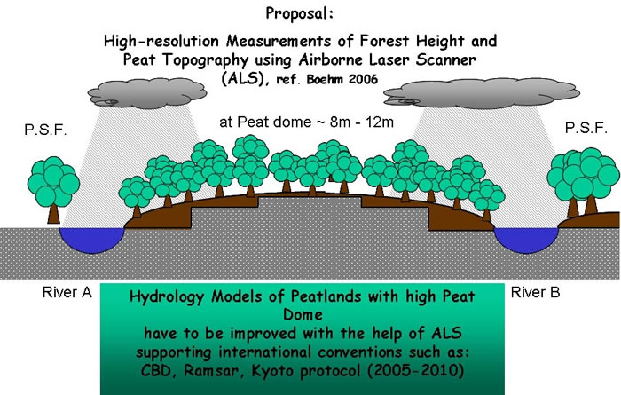
Carbon Storage in the Northern Sabangau Area between Tangkiling and Kasongan, Central Kalimantan and Peatland DEM-measurements with an Airborne Laser Scanner, 4-2007
Symposium on Carbon in Peatlands
15 – 18 April 2007 Wageningen, the Netherlands
Dr. H.-D. Viktor Boehm 1) and Dr. Yustinus Sulistiyanto 2)
1) Kalteng Consultants, Kirchstockacher Weg 2, D-85635 Hoehenkirchen near Munich Germany,
Email: ViktorBoehm@t-online.de; www.kalteng.org
2) University of Palangka Raya, Indonesia
Keywords: Peat Land Topography, Airborne Laser Scanner (ALS), Peat Drilling, Carbon Storage, Fires, DEM
In 1997, 2002 and 2006 El Niño prolonged the dry season considerably causing strong fires, haze and smoke in Central Kalimantan. The peatland fires during the dry season have greatly increased, caused mainly by the Ex-Mega-Rice Project (MRP). To understand better the situation of that area more than 90 peat drillings have been done in 2006 parallel to the Kalimantan highway along the transect Tangkiling and Kasongan. Results of these peat measurements showed a peat depth up to 8.10 m. The estimation of stored peat volume and carbon for the northern Sebangau Catchment and Palangka Raya between Katingan and Rungan rivers up to the border of the heath forest has a peat volume of 7.1 Gm³ (res. 5.93 Gm³).
The content of carbon in 1 cubic meter of peat has been measured to be 154.3kg. We found a stored carbon value of 0.92 to 1.1 Gtons for this area. The pH-values of water were very acidic and three soil samples showed a very low nutritional value. It will be necessary to rehabilitate this fragile peatland ecosystem. With a high-resolution Airborne Laser Scanner (ALS) the topography of peatlands will be measured in Feb. 2007 by an helicopter. Also the biomass of Peat Swamp Forest (PSF) will be analysed by this modern technology with an elevation resolution of +/-15cm. Additionally illegal channels in PSF will be monitored and the hydrology model of peatland improved.