
remote sensing

our work
kalteng remote sensing shows trends in environments like Kalimantan.
- TanDEM-X elevation model data for canopy height ...
- Monitoring Forest Threats with C- and L-band SAR, ...
- Ground Penetrating Radar Mapping of Peat ...
- Spectral Variability and Discrimination ...
- Kalteng Consultants Company Profile, Oct
- Visiting of Wetlands International Camp on ...
- Ortho Photo Mosaik von Kelurahan Tumbang Tahai ...
- Ortho-Photo Mosaik from Lake Batu, north of ...
- International Symposium & Workshop on Tropical ...
- The Contribution of CHRIS/PROBA Data for Tropical ...
- Workshop on Spatial Planning and new Remote ...
- Ortho-Photo Generation and Mosaiking of City ...
- Ortho-Photo Mosaik from Kecamatan Bukit Batu, ...
- International Workshop, Wild Fire and Carbon ...
- Planning Group for Kecamatan Bukit Batu gathered ...
- Carbon Storage in the Northern Sabangau Area ...
- Peat Land Topography derived from 30m Resolution ...
- Peat depth, minerals below peat, carbon, fires ...
- Carbon Storage in the Northern Sebangau Area ...
- Peatland Topography DEM-measurements with ...
- Precise Measurements of Peatland Topography and ...
- Environmental Management Study of the Tangkiling ...
- Environmental Field Trials and GIS Image ...
- Land Cover Change on Peatland in Kalimantan ...
- The Impact of Logging and Land Use Change in ...
- Tracks along the Kalimantan Highway from Kasongan ...
- Fires in 2002 monitored on the Landsat-images 14 ...
- The Amount of Carbon released from Peat and ...
- Land use Change in Central Kalimantan over the ...
- Remote Sensing and Aerial Survey of Vegetation ...
- Monitoring land cover and impacts, Remote Sensing ...
- Fire Impacts and Carbon Release on Tropical ...
- Ecological Impact of the one Million Hectare Rice ...
- Land Use Change and (Il)-Legal Logging in Central ...
- Peat fires in Central Kalimantan, Indonesia: Fire ...
- Environmental Helicopter Flight Trails with ...
- Impact of the 1997 Fires on the Peatlands of ...
- Application of Remote Sensing and GIS to monitor ...
- Monitoring of 1997/1998 Fires and Burnt Scars in ...
- Flight survey over the Mega Rice Project and over ...
- Application of Remote Sensing and GIS to survey ...
- Mega Rice Project in Central Kalimantan, ...
- Satellite Images and Aerial Photos from the ...
- The need for better
- Remote Sensing Verification by Aerial Surveys and ...
- NATURAL RESOURCE FUNCTIONS, BIODIVERSITY AND ...
- Excursion to Central Kalimantan, ...
- Satellite Images and Aerial Photography’s from ...
- Symposium of International Peat Society, ...
- Indonesia Travel to Jakarta, Bali and Kalimantan ...
- The Mega Rice Project Central Kalimantan ...
- Land Use Planning and Environmental Monitoring in ...
- Bildverarbeitung von Sensorbildern zur Erstellung ...
- GIS-Workshop, Camp km48 Sangai.
- Monitoring Land Use Change on Tropical Peatland ...
- Seminar on Scientific Implications of the ...
- Report of Ground Truth Campaigns incl. Aerial ...
- Ground and Helicopter verification of Satellite ...
- Environmental Detection from Satellite and ...
- First visit to Central Kalimantan in June 1995, ...
- Environmental Helicopter with Modular Sensor ...
- Remote Sensing with a Thermal Imager on an ...
- The Use of an Environmental Helicopter for the ...
- EUROMAR-SEASTARS a Modular Multi-Sensor System ...
gallery

image gallery
Find a large collection of images from many years of exploration by kalteng-consultants.
History Borneo - Kalimantan · Excursions to peatland 1996 · Mega Rice Project 1999 · 2004 · 2005 · 2006 · 2007 · 2008 · 2009 · 2010 · 2011 · 2012 · 2013 · 2014 · 2015 · 2016-March · 2016-August ·
remote sensing
Remote Sensing and Aerial Survey of Vegetation Cover Change in Lowland Peat Swamp of Central Kalimantan during the 1997 and 2002 Fires; 9-2002
TROPEAT-Symposium,
18-19 Sept 2002, Bali, Kuta, Indonesia
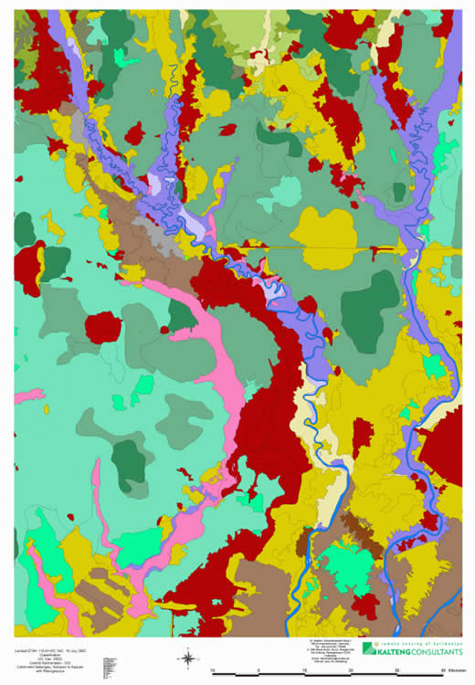
Land cover change map derived from the April 1996 and Oct. 1997 interferometric SAR
datasets. The areas affected by the 1997 fire are coloured in red and orange.
kalteng_2002-28-TROPEAT-RS and Aerial Survey-06-01-2003_Boehm.pdf
by
H.-D.V.Boehm, F. Siegert & S.C. Liew
Abstract
Peat swamp forests play important roles in the regulation of hydrology, the maintenance of biodiversity and in global climate regulation. In tropical areas they are being depleted by logging and land conversion activities, especially by fires. In autumn 1997, fire raged out of control in the "Mega-Rice Project" area in Central Kalimantan, Indonesia, where over one million hectares of land was earmarked for conversion into agricultural land.
The impact of this fire on the vegetation in this area was studied using satellite remote sensing imagery and by ground and aerial surveys. This study focuses on the use of interferometric synthetic aperture radar technique in mapping vegetation cover change. ERS SAR imagery over the area of interest was acquired during two tandem missions in April 1996 and October 1997. The change in vegetation cover was mapped by comparing the change in coherence and backscatter intensity.
The results of the ERS SAR analysis were checked on the ground and during aerial surveys in part of the study area in June and November 1998 and August 1999. Comparison with SPOT images acquired during the fire period and Landsat TM images acquired before and after the fire period confirms the interpretation of the ERS interforemetric SAR images. NOAA images to count hot spot information were also used. New huge fires were observed in autumn 2002 (End July to End of October) over the island of Borneo caused by draughts of the next El Nino Southern Oscillation (ENSO) five years later. Fires and smoke can be detected with the NOAA and with the MODIS sensor (e.g. on 18. Aug. 2002) covering the whole period. It seems that now every year for several months during the dry period smoke and haze conditions around Palangkaraya and the MRP area become the norm.
